| Project
|
- Name - Used to
enter a name for the project.
- Project
Path - Displays the file path to the project.
- Units - Used to
select between IP-Imperial and SI-Metric units systems for the project. The
units system selected here persists throughout the user interface where units
are displayed.
- Units
Format - Used to set the units format using the IP-Imperial units
system. The options allow you to display values using either decimal or
fraction formats. Units Format is disabled when the project units are set to SI
- Metric.
- Calculation
Standard - Used to set the default calculation standard used by the
project; ASHRAE or CIBSE.
OpenBuildings Energy Simulator is capable of computing
and reporting on energy calculations using both standards.
|
| Regional
|
- Continent -
Used to select the continent on which the project being validated is to be
located. Selecting a continent here narrows the available location information
in the following regional settings.
- Country - Used
to select the country in which the project being validated is to be located.
The drop-down list is filtered to only list the countries with weather stations
located on the selected continent.
- State/Province
- Used to select the state or province in which the project being validated is
to be located. The drop-down list is filtered to only list the states or
provinces with weather stations located in the selected country.
- Location - Used
to select the weather station location the project being validated is to be
associated with.
- Weather
Profile - Used to select a weather profile database to use for the
project being validated. Weather profiles from around the world are listed.
- Climate/Moisture
Zone - Used to set the climate and moisture zones in which the
project site is located. Climate zones are specified with a number (1 through
8) and moisture zones, a letter (A, B or C).
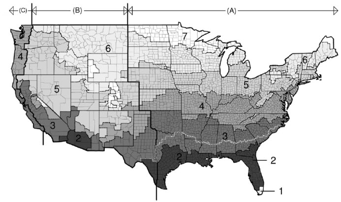
The
2006 International Energy Conservation Code (IECC) Climate Zone map of the
continental United States of America
|
| Building
|
- Catalogue -
There are three ASHRAE catalogs; 2004, 2007 and 2010. When one is selected,
only the building and room types from the selected ASHRAE catalog are displayed
in the Building types tab.
- Building
Type - Used to select from a catalog of building types.
OpenBuildings Energy Simulator provides two building
type catalogs based on the calculation standards from ASHRAE and CIBSE.
- Orientation -
Used to set the orientation of the building. Orientation refers to solar
orientation which is the siting of the building with respect to solar access.
The orientation value entered here defines the angle between the building
y-axis and true north in the clockwise direction. A rotation of 180 degrees
flips the building around so that the north (or back) facade is facing south
(or front).Orientation has an impact on heating, lighting and cooling costs. By
maximizing southern exposure, the building design can take advantage of the sun
for daylight and passive solar heating. This results in lower cooling costs by
minimizing western exposures, where it's most difficult to provide shade from
the sun.
|
